IMU-GPS Logger
The IMU-GPS data logger includes a set of motion sensors as well as a Global Positioning System (GPS) feature. The set of motion sensors include a 3-axis accelerometer, a 3-axis gyroscope, a 3-axis magnetometer, and a precision barometric pressure sensor. The GPS feature adds location data at samples rates up to 10 Hz. Combined, the motion sensors and GPS data provides complete orientation and location information. Time stamps are disciplined to GPS time.
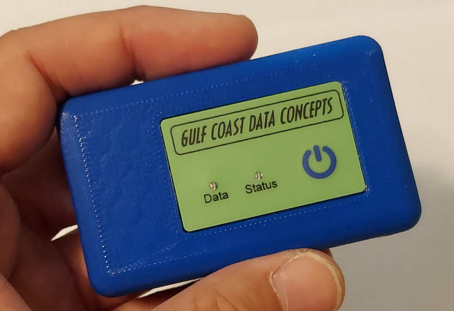
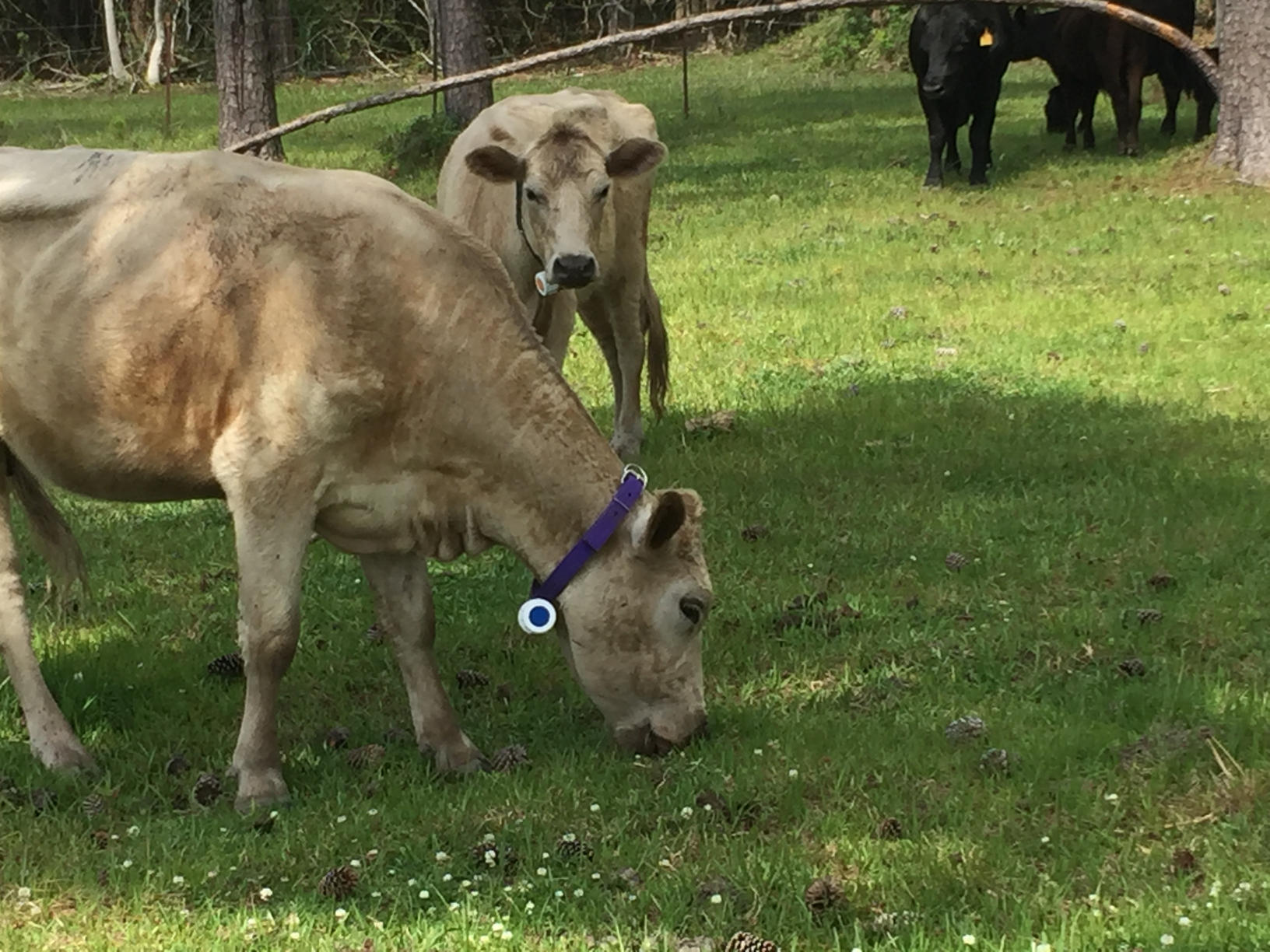
GCDC designs and asssembles data loggers "in-house" so we can customize the IMU-GPS product to fit specific needs. The pictured IMU-GPS (above) is enclosed in a 3D printed box measuring 3x1.8x0.8 inches. However, the logger can be easily repackaged into other configurations to accommodate customer requirements. For example, this logger was packaged into a waterproof enclosure with a large 5Ah battery. This allowed long term activity monitoring of cattle (see Applications below).
Please contact sales@gcdataconcepts.com for more detailed technical information, availability, and pricing.
Buy OnlineCompact and self-contained data logger Accurate time stamped data using Real Time Clock (RTC) and GPS Data recorded to microSD card Easily readable comma separated text data files Internal hardwired rechargeable Lithium-Polymer battery, charges via USB Data transfer compatible with Windows/Linux/Mac via USB interface (no special software required) 3-axis accelerometer: 2/4/8/16 G 3-axis gyroscope: 125/250/500/1000/2000 dps Accel/gyro sample rates: 12, 26, 52, 104, 208, and 416 Hz 3-axis magnetometer: 1, 20, 20 Hz High precision barometric pressure sensor GPS receiver with internal antenna
For more details, specifications, and how to use the IMU-GPS data logger, please refer to the user manual (.pdf). The user manual includes an example data file and instructions for converting the data and time stamps.
The logger is configured using a simple text file called config.txt located on the microSD card.
Data is stored to simple text formatted .csv type files, which are easily imported into any spreadsheet or analysis software (Matlab, Octave, R, etc). Below is a example data file:
        ;Title, http://www.gcdataconcepts.com, LSM6DSM, BMP384, GPS
        ;Version, 2476, Build date, Apr 17 2023,  SN:CCDC20235263491
        ;Start_time, 2023-05-31, 22:09:12.819
        ;Uptime, 5,sec,  Vbat, 4194, mv, EOL, 3500, mv
        ;Deadband, 0, counts
        ;DeadbandTimeout, 5.000,sec
        ;LSM6DSM, SR,104,Hz, Units, mG, mdps, fullscale gyro 250dps, accel 4g
        ;Magnetometer, SR,10,Hz, Units, nT, Temperature, 37,degC
        ;BMP384, SI, 0.100,sec, Units, Pa, mdegC
        ;Alt Trigger disabled
        ;CAM_M8 Gps, SR,1,Hz
        ;Gps Sats, TOW, 0, ver, 0, numSat, 0
        ;, gnssId, svId, cno, elev, azmith, prRes, flags,inUse
        ;Time, Ax, Ay, Az, Gx, Gy, Gz, Mx, My, Mz, P, T
        1685570953.732178,18,-12,1012,-866,-2328,-132,52734,3735,2868,101368,39951
        1685570953.741470,17,-12,1015,-813,-2442,-167
        1685570953.750762,17,-13,1016,-866,-2363,-184
        1685570953.760054,17,-12,1014,-857,-2450,-202
        1685570953.769346,18,-13,1014,-857,-2415,-245
        1685570953.778638,18,-12,1014,-840,-2407,-219
        1685570953.787930,18,-12,1014,-813,-2450,-219
        1685570953.797222,17,-11,1014,-831,-2459,-167
        1685570953.806519,18,-13,1014,-805,-2380,-210,52819,3509,2966,101366,39945,, 356975.000, 30.3602812,-89.1171477, -16.325,11.320, 283.780,200.663
        1685570953.815811,18,-11,1014,-866,-2372,-167
        1685570953.825103,18,-12,1015,-866,-2407,-167
        1685570953.834395,17,-12,1015,-875,-2424,-140
        1685570953.843687,19,-13,1015,-822,-2407,-193
        1685570953.852979,18,-12,1014,-848,-2407,-202
        1685570953.862271,18,-12,1015,-892,-2407,-158
        1685570953.871563,17,-13,1014,-875,-2354,-202
        1685570953.880860,18,-12,1014,-778,-2459,-167,,,,101370,39936
        1685570953.890152,18,-12,1016,-735,-2494,-193
        1685570953.899444,18,-11,1015,-621,-2564,-219
GPS location and activity tracking of cattle. The logger was packaged into a PVC plastic assembly and attached to the animal with a collar.

- Complete list of examples using our accelerometer product line